I can imagine what a momentous day it was on July 1, 1958, when the new Maple Street Bridge was opened. Perhaps many of you–like me–grew up with the bridge thinking it had always been there. However, it wasn’t always there. It was a long, uphill battle to get it built along with financing challenges.
Bridge Needed
There was an identified need as far back as 1931. The first official notice of the need for a bridge came in a 1931 pamphlet entitled the “By-Pass Plan” prepared by the city planning commission. It specified a bridge west of Monroe Street emphasizing Spokane’s growth and increasing traffic congestion even in 1931! However, no method of financing was proposed for the estimated cost then of $695,000. A study was completed in 1951 that recommended Maple and Ash Streets but the estimated cost ballooned to $5,192,000.
A Way to Finance the Bridge
The concern was how to provide the funds without disrupting the city’s financial structure and obligations. Various financing methods were considered. Among them were general obligation bonds, revenue bonds issued against income from the state gasoline tax or parking meter revenues, and the use of tolls. Never before had a Toll Bridge Authority (TBA) law been used by a city and the state for tolls. The TBA law was offered for use if the city was willing to have a complete engineering study made of the feasibility of financing the bridge through small tolls.
Additional surveys were done by traffic experts Coverdale & Colpitts in New York and the San Francisco-based Tudor Engineering company. It was through their surveys that a 10-cent toll fee was proposed for cars. The city council agreed to this method of financing.
Reasons for the Bridge
There were many reasons for having the bridge. Spokane’s population in 1910 was 104,402. In June, 1956, it was 186,000. There were fewer bridges across the river than in 1910. The survey prepared by Coverdale & Colpitts explained that the population in Spokane’s northwest section increased 24 percent in the five years between 1950 and 1955. The survey indicated it would be from that area the new bridge would draw its traffic.
Another important factor was approximately the 10,500 military personnel stationed in the area. Most of them would funnel into Spokane from the northwest section. Traffic was also expected to increase at the rate of 3 percent per year which factored into the recommendation of a new bridge. The new bridge would provide traffic relief which was needed for the Division, Washington, Howard, and Post Street bridges.
Traffic jams on the Monroe Street bridge were another example of the need for the Maple Street bridge. To those who traveled north on Monroe after work each evening, that main artery was packed with cars bumper to bumper.
For users of the new bridge, the 10-cent tolls would be paid at a toll plaza regardless of which direction they were going. Tolls would be five cents per axle—10 cents for cars which have two axles; and 30 cents for trucks with six axles.
The toll plaza would consist of three booths and three collection lanes for traffic in each direction. Bridge planners determined that by locating the toll plaza approximately midway between the north end of the river crossing and the start of the north approach that traffic congestion would be avoided.
The toll plaza would be similar to the San Francisco-Oakland Bay Bridge plaza with canopies over the collection lanes to protect drivers and toll collectors from inclement weather. The bridge was to be fully illuminated at night to increase driving safety and enhance its appearance. Toll collection would be by automatic devices with the motorist dropping a dime into a hopper slot and getting a green light to proceed. One lane of the toll plaza was to have a semi-automatic booth for making change and handling special vehicles.
Additional Funding
The state authorized issuance of a $6,000,000 bond to finance the construction of the bridge in May, 1956, with the four-lane span across the Spokane River scheduled to be opened to traffic in March, 1958. That event culminated 10 years of effort by city officials, the state legislature, and other individuals and groups. A study showed the bond issue could be paid off under the 10-cent toll charge for cars and 30 cents for trucks. The $6,000,000 bond issue was set up on a 40-year maturity basis issued with $4,500,000 of series A and $1,500,000 of series B bonds.
Finally Construction Begins
Work began on the bridge in June, 1956, with the construction of a deck plate girder 1,713 feet long. A dirt causeway was constructed across the river from the south side to enable workmen to complete the second of two giant foundation piers. Four spans of 150 feet each were constructed over the Spokane River and lower valley. To the south of these spans were 10 spans varying in length from 92 to 151 feet. Twenty-six piers were built to support the bridge from the Spokane River’s north bank to its juncture and loop at Riverside. The north approach went under Broadway instead of over it and the entry to the bridge from the north was two blocks north of Broadway. The bridge length was six blocks long.

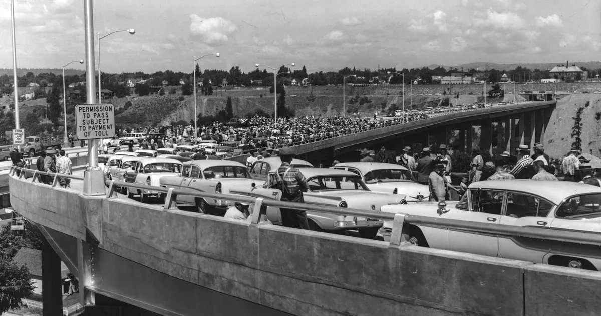
Bridge Opening Day in 1958
On July 1, 1958, a crowd gathered for the dedication and opening ceremony of the bridge. The bridge immediately took 40 percent of the traffic off the Monroe Street bridge after it opened.

Paying the Toll
Getting used to paying a toll was an adjustment for many using the bridge. There were traffic delays, as drivers fumbled to find coins. The coin chutes took combinations of coins “digested” by electronic machines that sensed the diameter of the coin.


The digesting of more than one coin took longer. Traffic was slower in the lane where the toll collector had to make change. The longer the digesting process, the longer it took for the red “stop light” at the plaza to turn green and allow motorists to pass. For those that missed the coin hopper, a bell would go off that was designed to be loud enough so that drivers would stop.
Two change makers were on duty 24 hours a day in the center lanes of the plaza. They were also called toll collectors and known as bridge “runners” who would retrieve dimes that were missed. There were still those that drove through without paying. One way that proved effective in curbing non-payment of the toll was to station a Washington State trooper at the bridge when surges in bridge running were detected but the personnel cost made it infeasible on a regular basis. It was felt it would cost the state more to increase enforcement procedures than would be recovered. There was a misdemeanor fine of up to $45 for evading the toll when a license number could be recorded.
Over the years, revenue loss plagued the bridge. During the first 10 years of operation, toll revenues did not cover bond interest, retirement obligations, and operational costs. Thus, deficits continued to mount. The legislature had to order loans from highway funds to the bridge to meet bond debt obligations. The original bonds were purchased by the Public Employees Retirement System and the Teachers Retirement System which were tied to a toll revenue that only paid off about $300,000 of the 40-year bonds in 1979.
On May 24, 1981, the toll was raised to 25 cents for cars except for vehicles carrying three or more people which would continue to pay a dime. Without an adjustment in the tolls, the state would have had to resort to a Motor Vehicle Fund to pay off the bridge bonds. It was felt the increased toll would not only meet the bond payments but there would also be $1.8 million in extra revenue through 1985 which was thought could be applied to speed up the payoff period of 1996.
Toll Removed in July 1990
However, a downturn in bridge traffic and lowered revenue eventually resulted in a 4-cent-a-gallon gasoline tax to pay off the remaining debt in 1990 and removal of the tolls on July 13, 1990.
Bridge Improvements and Beyond
Improvement projects thereafter included a $4,000,000 bridge re-decking which was expected to improve traffic flow north and south and reduce air pollution from slow-moving traffic. There was also $3.4 million spent that added wire netting and pipe to enclose the five-foot wide sidewalk to protect those in Peaceful Valley from falling debris from the bridge.
Gone are the debt challenges of the past. The Maple Street bridge remains an important transportation artery for Spokane. It has continued to carry its share of the traffic load averaging 45,000 cars a day in 2018 and will continue to play an important part as the community grows.

While the original toll booths have been removed, I would like to see the former toll-booth plaza converted into something with a more pleasing appearance such as a useful storm water retention area with landscaping to honor the bridge for its place in the history of Spokane.
Sources
- “Those Under Maple Span are Targets”, Spokane Chronicle, March 27, 1959, page 3.
- “New Maple Street Bridge Opened”, Spokane Chronicle, July 1, 1958, page 1.
- Nikolai Cherny, SpokaneHistorical.org, “The Maple Street Bridge”, accessed June 11, 2022 (https://spokanehistorical.org/items/show/93).
- Wikipedia, “Maple Street Bridge (Spokane)”, accessed July 22, 2022 (https://en.wikipedia.org/wiki/Maple_Street_Bridge_(Spokane,_Washington)).
- Doug Floyd, “Traffic Toll is Lower on Maple Street Bridge”, Spokane Chronicle, September 14, 1981, page 3.
- Jesse Tinsley, “Then and Now: Maple Street Bridge”, The Spokesman-Review, April 1, 2019, page 1.
- “Toll Bridge Losing Too Much Money”, The Spokesman-Review, August 14, 1980, page 20.
- “Bridge’s Toll to be 25 cents”, The Spokesman-Review, April 21, 1981, page 1.
- Julie Sullivan, “Toll Sounds for Bridge Keepers”, Spokane Chronicle, July 13, 1990, page 1.
- “Maple Street Bridge Refinancing Approved”, Spokane Chronicle, October 24, 1979, page 5.
- Robert Harper, “Maple Street Bridge Refinancing Ok’d – Clears Way for City’s New Span”, The Spokesman-Review, October 24, 1979, page 1.
- “Maple Street Bridge Legislation Lauded”, The Spokesman-Review, March 28, 1979, page 40.
- Fred Leeson, “Spokane’s Economic Gauge: Maple Street Toll Bridge, The Spokesman-Review, July 30, 1972, page 6.
- John L. Lemon, “Toll Bridge Favored”, Spokane Chronicle, December 7, 1968, page 3.
- “Spokane River Bridge Plans Get Signature”, Spokane Chronicle, April 23, 1969, page 27.
- “Maple Span Traffic Off”, Spokane Chronicle, May 25, 1981, page 3.
- “Bridge Illustrates Costs Spiral, The Spokesman-Review, June 10, 1956, page 8.
- “Toll on Maple Bridge to be Taken at North”, Spokane Chronicle, July 19, 1956, page 17.
- Doug Floyd, “Bridge Runners Take Toll on Span”, Spokane Chronicle, December 15, 1980, page 1.
- “Toll Bridge Figures and Data are Given by State Authority”, Spokane Chronicle, June 16, 1956, page 1.
- “Stadium Goers Need Maple Street Bridge”, The Spokesman-Review, August 28, 1956, page 4.
- “TBA’s Action Clears Way for Span”, Spokane Chronicle, May 17, 1956, page 3.
- “Maple Traffic Waits – It Takes Time to Find a Dime”, The Spokesman-Review, July 13, 1958, page 8.
- “Maple Street Traffic Jumps”, Spokane Chronicle, September 13, 1967, page 30.
- “Maple Street Bridge has Best Year”, Spokane Chronicle, December 14, 1970, page 3.
- “Want to Buy a Bridge?”, The Spokesman-Review, January 23, 1984, page 5.
Image Sources
- Maple Street Bridge 1958, Northwest Museum of Arts & Culture/Eastern Washington State Historical Society, Charles Libby Collection, L87-1.91632A-58.
- Jesse Tinsley, “Then and Now: Maple Street Bridge”, The Spokesman-Review Archives, April 1, 2019, page 1.
- Maple Street Bridge, April 1957, Northwest Museum of Arts & Culture/Eastern Washington State Historical Society, Charles Libby Collection, L2009-12.7.17.
- Aerial View of Southwest Spokane, 1959, Northwest Museum of Arts & Culture/Eastern Washington State Historical Society, Charles Libby Collection, L87-1.653-62.
- Maple Street Bridge Toll Booth, Northwest Museum of Arts & Culture/Eastern Washington State Historical Society, Charles Libby Collection, L2009-12.7.181.
- Maple Street Bridge Toll Booth, Northwest Museum of Arts & Culture/Eastern Washington State Historical Society, Charles Libby Collection, L2009-12.7.184.
- Aerial View of Southwest Spokane, 1959, Northwest Museum of Arts & Culture/Eastern Washington State Historical Society, Charles Libby Collection, L87-1.653-62.