This article on Peaceful Valley is a sequel to the one I wrote on the Maple Street Toll Bridge, as their histories are linked together. Peaceful Valley is one of Spokane’s first neighborhoods and one of the most historic.
The Early Days
In the early days of the settlement of Spokane, the valley remained what it had been for many years—a bustling, seasonal, fishing camp. In the 1880s, the Northern Pacific Railroad and Spokane and Inland Empire Railroad owned large portions of the area. After the railroads began selling off parcels, the neighborhood’s isolating geography kept it undeveloped. The only way in or out of it at that time was on steep switchback trails. When the city’s streetcar network was first being built in 1888, no tracks came down the steep slopes.
The neighborhood was referred to as Spring Flats at the time for its reputation as a serene place for Spokane residents to have a riverside picnic. The name quickly transformed to reflect the shacks that sprung up in the area, as migratory workers and poor immigrant families gravitated there.
In 1891, the Spokane Falls Review ran an article headlined “Clearing Poverty Flats”—replacing the name of Spring Flats. The name changed to reflect inhabitants of families in very humble circumstances. Work to clear the land of poor folks would not last, however. The area was close to town and attractive to poor immigrants and transients.
In 1893, real-estate developer, C.F. Clough, sold several lots but he needed to solve a serious marketing problem—the name of Poverty Flats. He rebranded the area as Peaceful Valley. He borrowed the name from an 1893 comedic play by Edward E. Kidder. The old name didn’t do justice to the industrious, hardworking people who lived there.
The Panic of 1893 limited building; but in the next decade, many homes were built which were relatively modest. The houses were largely simple, wood frame workers’ homes, one to two stories in height, and built close together on narrow lots. Decorative trim was often carved by the owners themselves. The more modest “row cabins” were several small, one-room dwellings attached to each other often by a single roof. They were rented to seasonal workers.
Working-class families—most of whom were immigrants—purchased lots and built homes. They were the stonemasons, carpenters, millworkers, lathers, bricklayers, plumbers, teamsters, lumberjacks, cooks, and laborers who worked long hours for low pay. Among them were Finnish, German, Swedish, Norwegian, Irish, African American, and Italians. They came for the region’s logging and mining jobs. Many of these families found work at a smelter in Northport near the Canadian border and then moved to Peaceful Valley when those jobs ended. Bachelors—mostly loggers, farmers, and miners—spent the off-season in small Peaceful Valley homes.
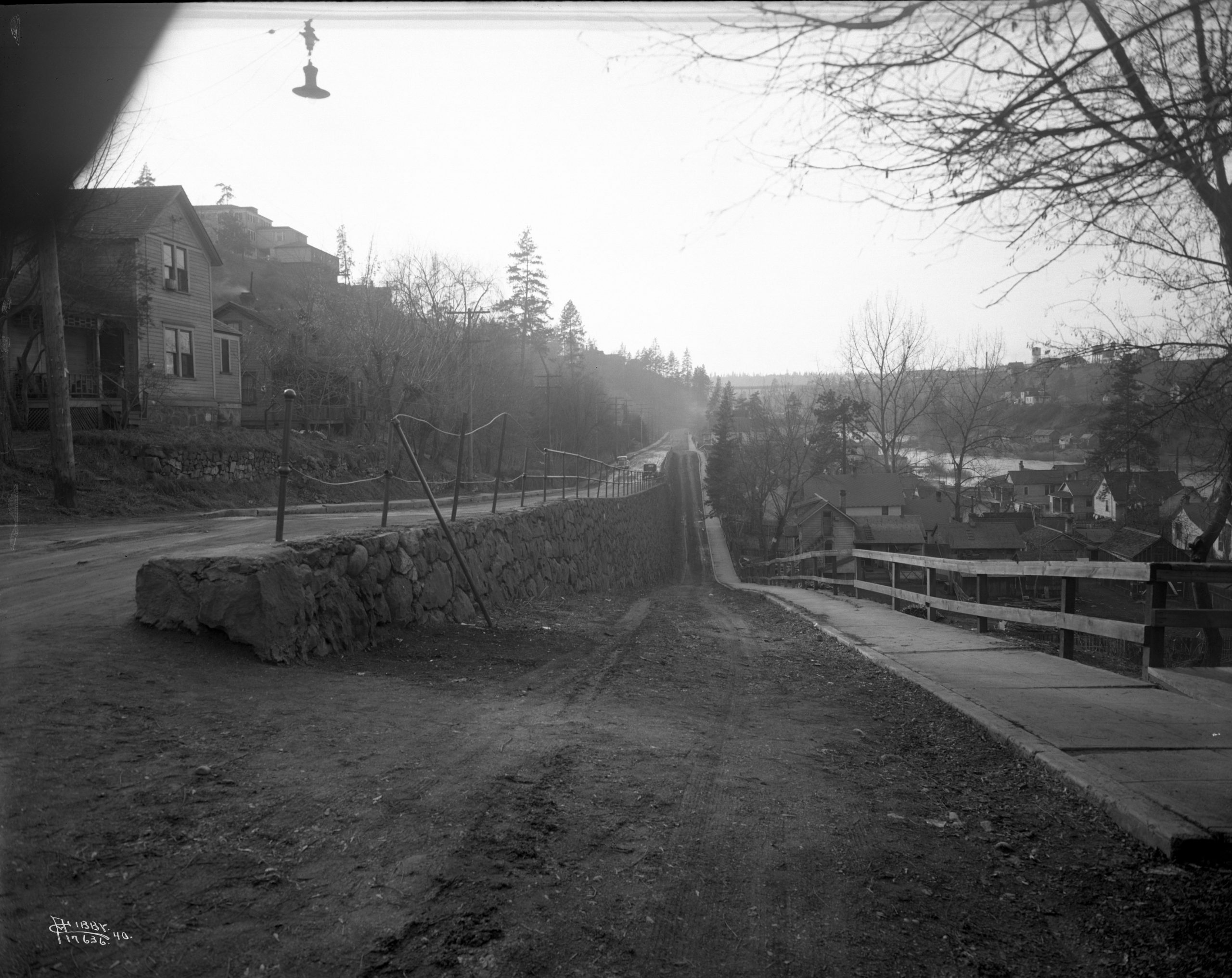
The roads in Peaceful Valley were a problem. They were narrow, winding, and muddy. In 1897 residents petitioned the city to build a road down the steep slope wide enough for the passage of two teams of horses. They raised the money to match the city’s share. The resulting road called Main Avenue passed under the south end of the old Monroe Street Bridge but it was steep and unpaved. Eventually when the concrete version of the Monroe Street Bridge was built in 1911, Main Avenue was given a more gradual grade but it was still a steep two-or-three-block slog up to Monroe Street and downtown.
The children fortunate enough to go to school also had a challenge with navigating the steep paths to attend the big, brick Washington School in Brown’s Addition. It was a dangerous climb for them. Mothers in Peaceful Valley asked that a school be built. In 1917, the school board finally built a two-room brick school called Cowley School named after Spokane pioneer H.T. Cowley. The school opened in September 1917 but it would only accommodate the first and second grades because it was thought older children were strong enough to make the climb up to Washington School.
The Spokane Casket Company
By 1910, nearly every lot had a house and there were even a few commercial buildings. One of the most significant buildings was the Spokane Casket Company. It was important to the economic growth of Spokane for almost 100 years.
Other shops also sprang up including groceries, butchers, barbers, saloons, and laundries. These small neighborhood businesses were especially important considering how difficult it was to climb the slopes out of Peaceful Valley into the commercial district of Spokane.
Also by 1910, the Finnish community was so robust that a Finnish Social Hall was built at 2022 West Clark Avenue. It was one of the largest structures—a three-story frame building with a first-floor dance hall and stage, a basement kitchen, and a third-floor apartment for the caretaker. The hall hosted plays, concerts, Christmas gatherings, athletic events, vaudeville acts, and community meetings. The hall was used for decades.
Development of Glover Field
In 1907, the Spokane Park Board was formed to oversee all of the city’s parks and future parkland and develop future parks. The board believed there was a need for an athletic stadium near downtown. The Park Board felt the city needed a place to host athletic events for school kids, high school and college athletes as well as for games between social club teams.
In 1912, the Spokane Parks Board purchased a nearly three-acre site at Main Avenue and Wright Street for a stadium and athletic field.
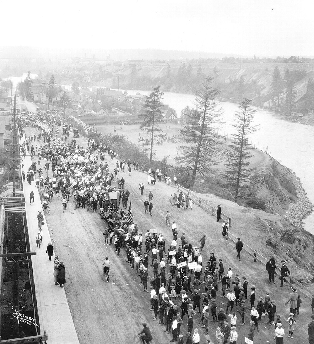
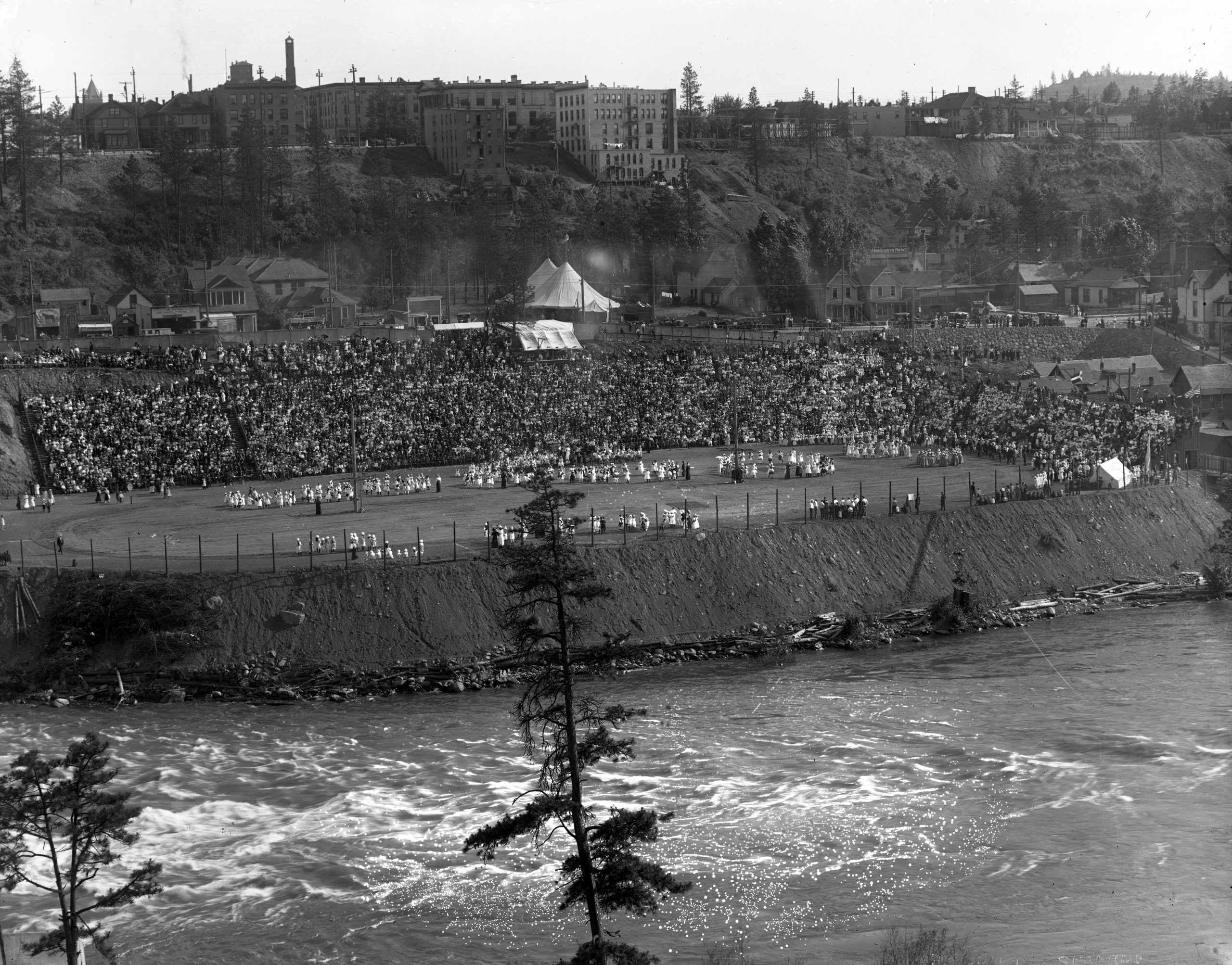
Workers carved out a semicircular hillside and lined it with wooden bleachers to accommodate 10,000 spectators and a six-lane running track. A flat play field was formed along with a running track, baseball backstop, football field and other amenities. It was used by local high schools for track meets and football games, as well as fairs, shows, and carnivals.
In 1917, the Park Board asked for suggestions for a unique name for the park. The Spokane County Pioneer’s Society, the Ad Club of Spokane, and the Chamber of Commerce all agreed that the name of “Glover Field” would honor the city founder, James N. Glover.
Many athletic and social events were held there in the past century. It was a camping area for visiting Native leaders and visitors attending the 1925 and 1926 Indian Congress meetings.
In 1937, the bleachers were dismantled as they fell into disrepair. By then, most high schools had their own athletic fields.
On November 22, 1949, a barrack was purchased from Geiger Field for a new recreation center in Peaceful Valley. The recreation center was funded by the Junior League of Spokane to give the children of the area a safe place to play and learn. It was opened on June 9, 1950. The center hosted activities including arts and crafts and outdoor games as well as meetings and potluck dinners. The community center was a place where the citizens of Peaceful Valley could discuss concerns and issues. The center—now called the Lower Falls Community Center—is still thriving today with outreach and children’s programs, a foodbank, and a free clothing program.
In 2018, the name of the park and the adjoining Peaceful Valley River Walk was changed to Redbank Park at the request of the Spokane Indians baseball team and the Spokane Tribe of Indians who have cooperated on projects to bring awareness to the plight of the native trout species.
The Northwest Indian Congress 1925 and 1926
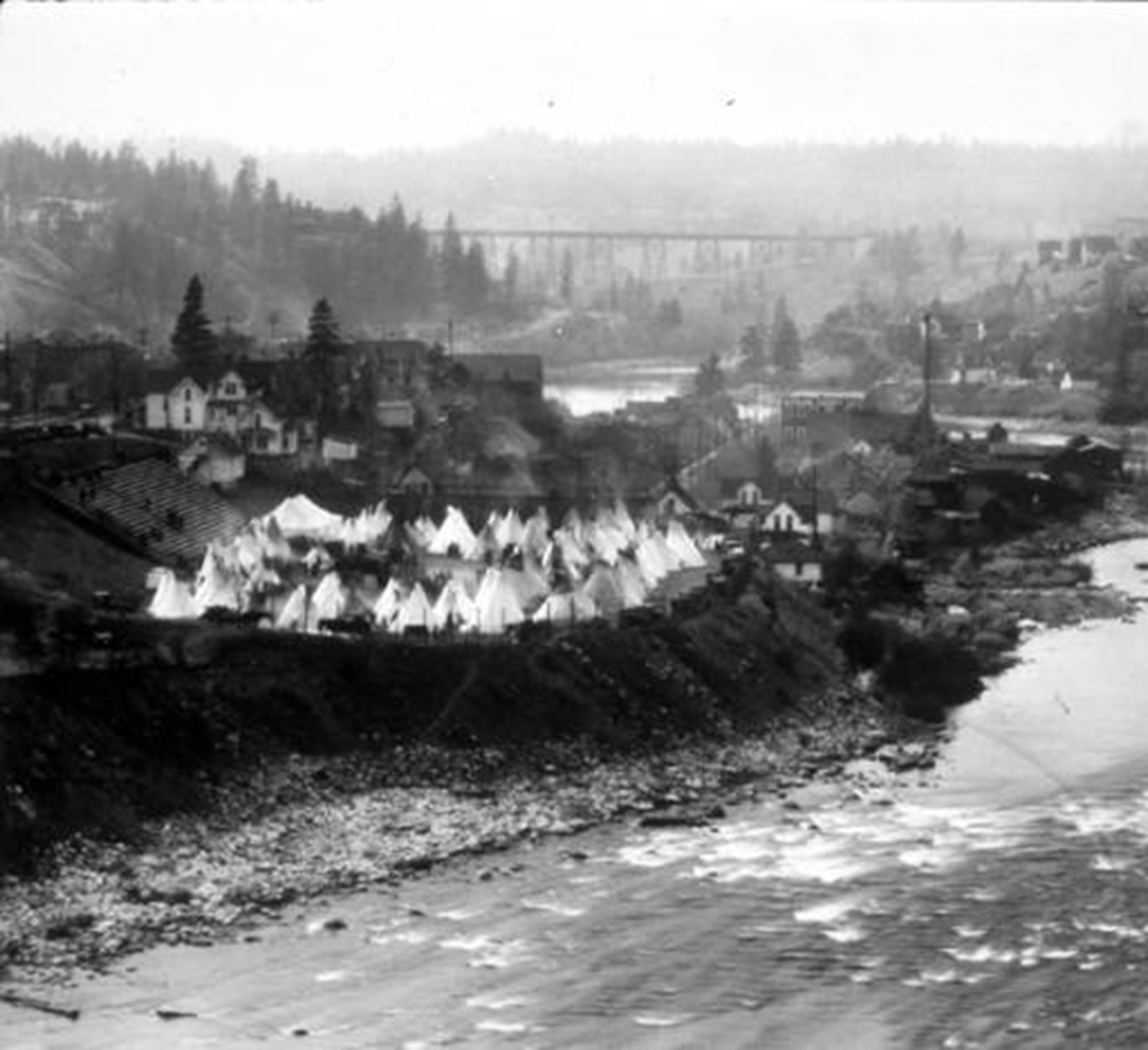
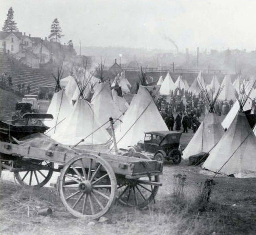
On October 30, 1925, delegates from 28 tribes (nearly 1,000 Indians) gathered in Spokane for the first Northwest Indian Congress. Glover Field was used on October 30 and 31, 1925, when tribal members pitched 88 tepees on it.
The Northwest Indian Congress came about from an unlikely source. The Gonzaga University football team had scheduled a home game on October 31, 1925 against the Haskell Institute of Lawrence, Kansas (the Haskell Indian Nations University as it came to be known). Haskell had a famous football program and had beaten several major college football teams. Spokane’s civic leaders realized that the game was likely to draw many tribal leaders. The mayor formed a committee which included city officials, Gonzaga priests, railroad officials, and prominent Indians that became known as the Spokane Betterment League. The gathering of tribal leaders was partly to draw attention to Indian issues and partly to draw tourists to Spokane.
The committee invited 34 Northwest tribes to attend and raised $18,000 to stage the event. As an incentive to create a picturesque Indian village, the committee paid $5 to each of the Indians who agreed to pitch their tepees on Glover Field and would also supply them with food and fuel.
Representatives from 28 tribes came to the event. The federal Chief Special Indian Officer, L.O. Shirley, arrived in advance to help preserve order among the visiting Indians to force out suspicious renegades who followed Indians around the country to prey on them.
Never since the days of the Indian wars had so many tribes gathered together. The official sessions focused on the serious issues of tribal welfare and citizenship. There were speeches, educational sessions at Spokane’s Masonic Temple, a parade, a football game, and a beauty pageant of Indian princesses waring War Bonnets. The event was purposely combined with a Halloween festival and parade. Many Indians in full regalia took part in the parade and cash prizes were awarded to those best costumed. The climax of the weekend was the Gonzaga-Haskell football game. Haskell won in thrilling fashion, 10-9, in front of a crowd estimated at 10,000. There was a procession before the game that included a procession of mounted Indians.
On the last day of the congress, the assembly voted to hold an even bigger meeting in 1926. It also voted to make the congress national in scope and rename it to the National Indian Congress with meetings to be held in the summer instead of the fall which could be colder.
The second congress was held July 23 through 26, 1926, in Spokane. Predominantly it was a Northwest tribal gathering even though a few more tribes attended from around the country including Nebraska and Colorado. The Indian attendance was approximately 1,000 which was about 10 percent more than in 1925. The tepee village at Glover Field was larger with 112 instead of 88 in 1925.
The good feelings from the event in 1925 were not the same in 1926. There was a “sometimes tense” nature surrounding the second congress that revolved around Indian education and control over their affairs.
The 1926 National Indian Congress ended with promises to continue the event annually but hints of dissatisfaction were prevalent. The congress became just an opportunity to air grievances instead of striving to be more than that. In the end, all efforts to continue the congress failed due to a general lack of enthusiasm.
The Neighborhood
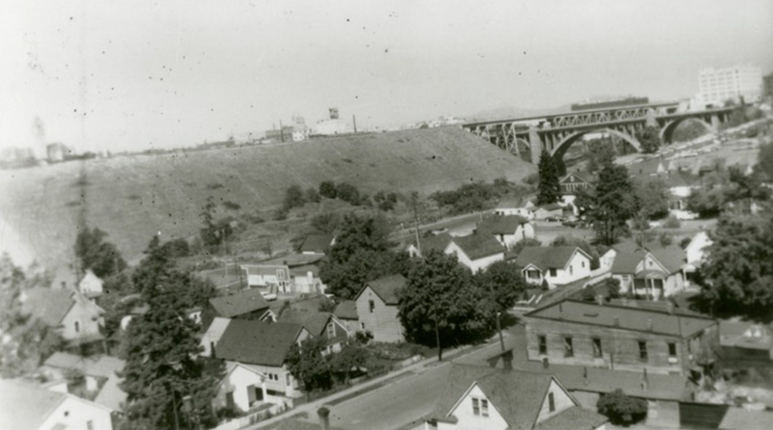
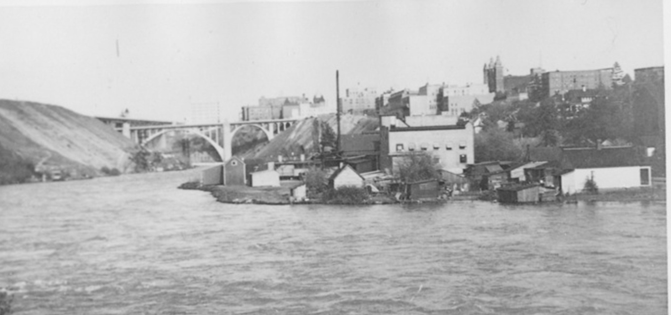
More than any other neighborhood in Spokane, Peaceful Valley’s identity was shaped by the Spokane River. Flooding became a problem for residents in high-water years where the river had a prominent rounded pool—residents called it a bay—at the western end. It was later filled to ease flooding problems.
The Spokane River was Peaceful Valley’s playground. Children would swim across despite the current but most residents chose the drier option of rowboats and canoes to cross. Fishing was also popular but salmon fishing ended with the completion of three dams (Nine Mile Falls, Little Falls, and Long Lake) between 1908 and 1915.
Peaceful Valley was a quiet, working-class area throughout the 1930s and 1940s. During the Great Depression years, more widows took on boarders to make ends meet at that time. Sanitation improved in the 1930s, as sewer lines were installed. Cowley School closed in 1930 due to a shortage of funds and a declining student population so children had to resume the long climb to Washington School.
Gold Fever
In the middle of the Great Depression, the Spokane Chamber of Commerce declared a gold rush in Spokane. Captain J. Richard Brown, a mining engineer, gave nine speeches at the relief kitchen on Trent Avenue to convince unemployed men and women to attend a mining school. The purpose of the mining school was to train them to go into the hillsides of Montana, Idaho, Washington and British Columbia to pan for gold.
On June 10, 1932, the Spokane Daily Chronicle reported there was 2,000 men and women who attended the school. Hands-on training took place in Peaceful Valley on the riverbank where instructors showed the students how to pan for gold and operate mining equipment.
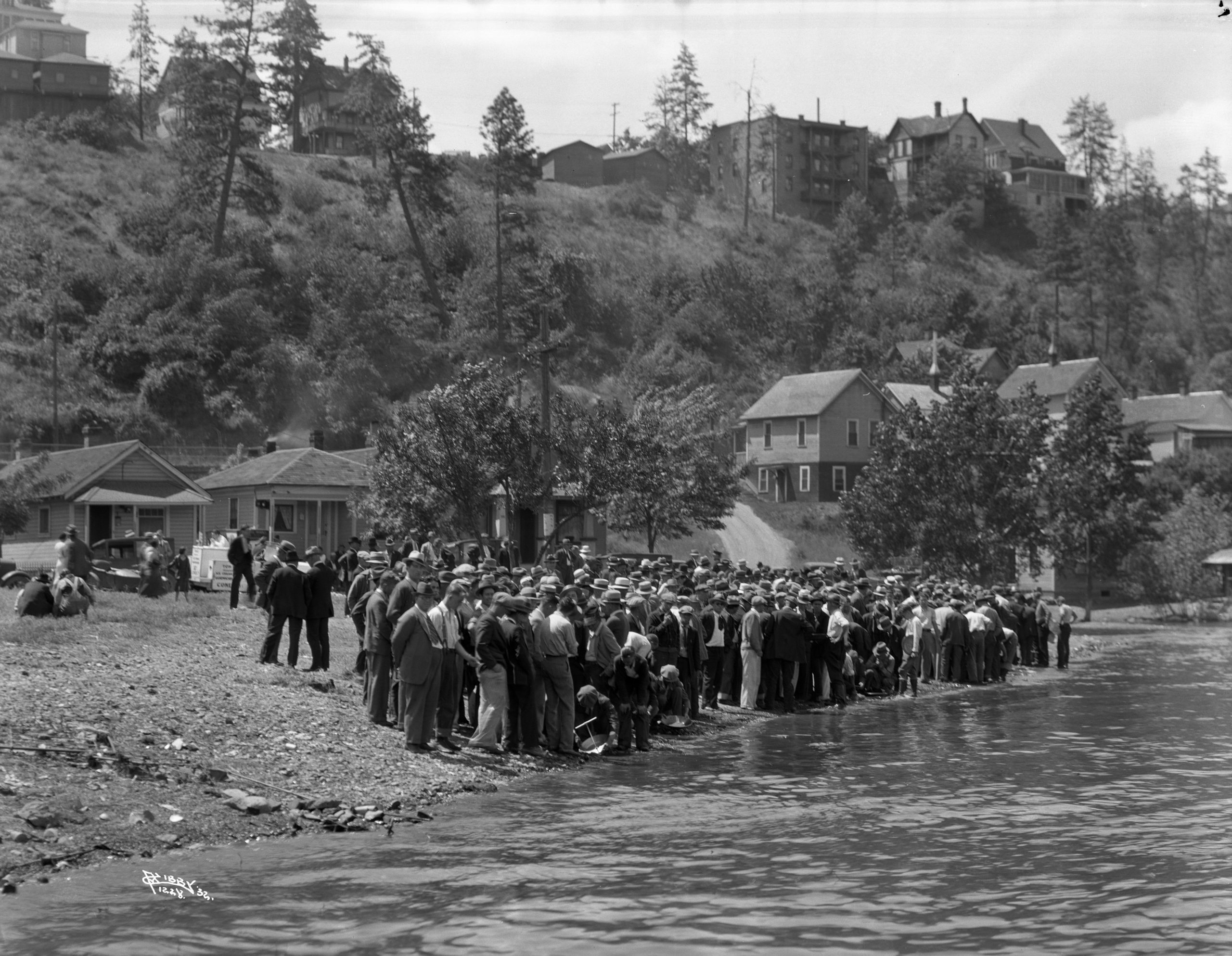
After their training, thousands set out in hopes of striking it rich. Despite their enthusiasm, little gold was found.
The War Years
The World War II years brought an increased demand for inexpensive housing as workers sought work in military installations and aluminum plants. Many of the old houses were converted into apartments.
Building of the Maple Street Toll Bridge
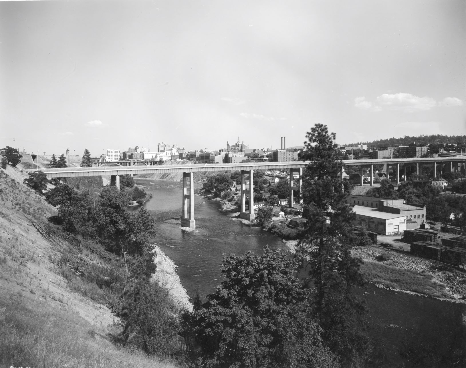
The most profound change in Peaceful Valley occurred when the massive Maple Street Toll Bridge was built in 1956 which was high overhead and straight through its center. Long-time residents on several blocks saw their homes torn down to make way for the bridge to accommodate the massive piers. The concrete bridge supports—rooted in the heart of the valley—were viewed by many as an ugly intrusion and a symbol of the city’s attitude toward the neighborhood.
The empty land left underneath the bridge became a barren, refuse-filled dust bowl. A “Beatnik Park” sign was erected in 1959 by residents objecting to the lack of care given state-owned property under the Maple Street Bridge. They claimed the area was weed grown and littered with debris tossed from the span.

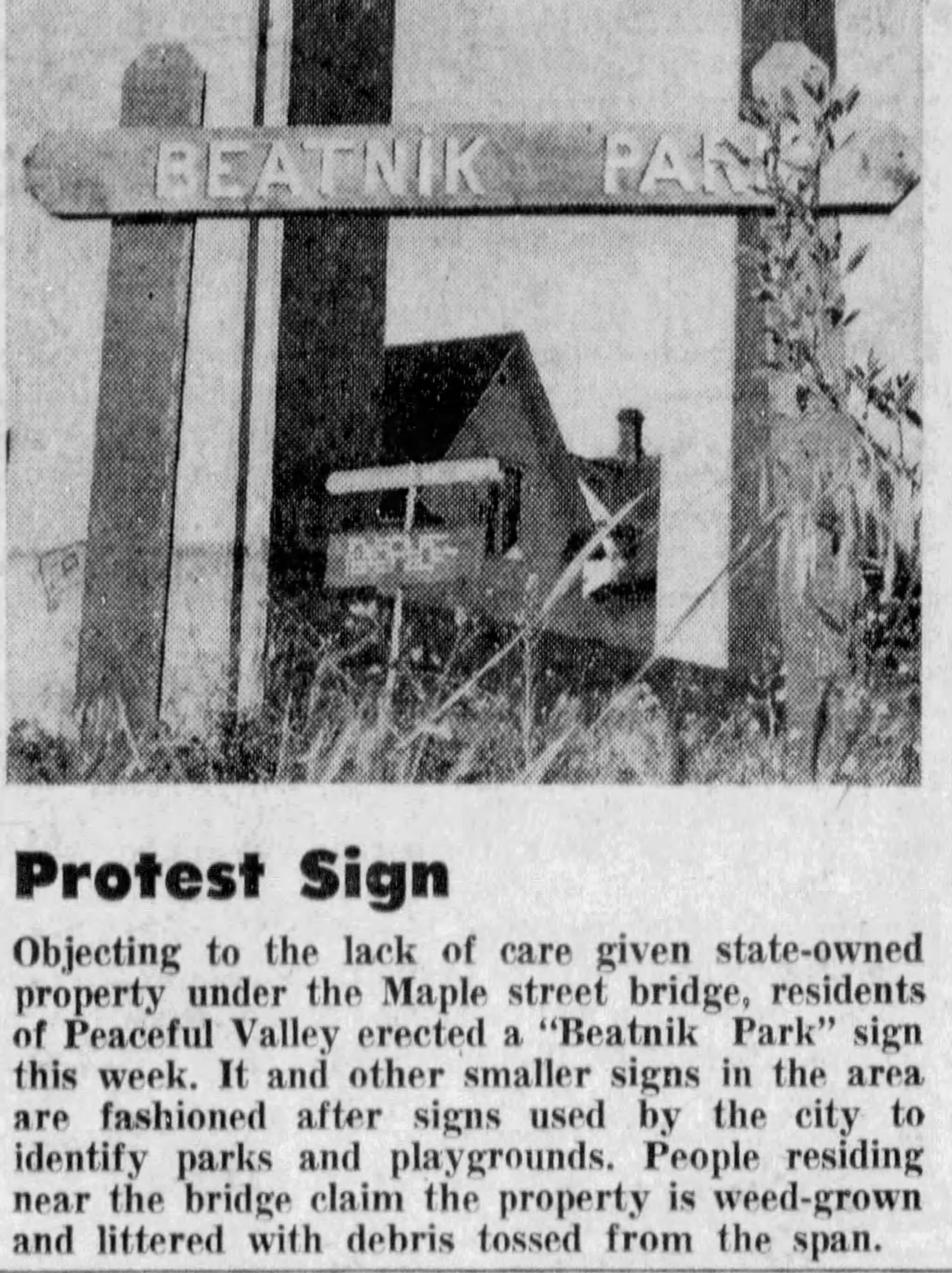
It was bad enough living with those gray concrete pillars obscuring the sun but to make matters worse people would throw bricks and other things off the bridge that would dent cars and put holes in roofs—fortunately no one was killed. An improvement was made in 1983 on the bridge with pipe and wire netting added to enclose the five-foot wide sidewalk to stop objects from being thrown from it.
In the late 1950s, 1960s and 1970s, Peaceful Valley gained a reputation as a counterculture area partly because of its low rent but also because of its reputation as a haven for iconoclasts and political mavericks. It also developed a reputation as an inexpensive area for artists and musicians with a low-key, unpretentious atmosphere. The cheap rent, the fact that Peaceful Valley is so close to downtown, the beautiful setting by the river, and its image of a forgotten little neighborhood continued attracting people to the area.
In 1984 in recognition of Peaceful Valley’s historic integrity and vital link to the heritage of the working class of Spokane, it was named to the National Historic Register.
There has remained a core of longtime residents whose homes have been neatly kept. They are happy to see newcomers who buy and renovate old run-down houses breathing new life into the neighborhood. Residents in Peaceful Valley are survivors bonding together to preserve the character of a unique Spokane neighborhood.
Sources
- Michael Schmeltzer, “A Frontier in the City”, The Spokesman-Review, November 14, 1982, pages D1, D5.
- Nicolas Deshais, “Peaceful Valley’s Climb”, The Spokesman-Review, December 3, 2018, pages A1, A6.
- Nikolai Cherny, “The Demise of Shack Dwellers”, SpokaneHistorical.org, accessed September 6, 2022 (https://spokanehistorical.org/items/show/92).
- Nikolai Cherny, “The Spokane Casket Company”, SpokaneHistorical.org., accessed September 6, 2022 (https://spokanehistorical.org/items/show/37).
- Nikolai Cherny, “A Working Man’s Neighborhood”, SpokaneHistorical.org., accessed September 6, 2022, (https://spokanehistorical.org/items/show/88).
- United States Department of the Interior, National Park Service, National Register of Historic Places, Inventory – Nomination Form, Peaceful Valley Historic District, March 23, 1984 (https://catalog.archives.gov/id/75613391) accessed June 4, 2022, pages 1-4.
- Jim Kershner, “Peaceful Valley (Spokane)”, July 6, 2017, HistoryLink.org (https://www.historylink.org/file/20402), accessed October, 2022.
- Jim Kershner, “Hundreds of Delegates from 28 Northwest Tribes Gather in Spokane for the first Northwest Indian Congress on October 30, 1925”, July 12, 2017, HistoryLink.org (https://www.historylink.org/file/20403), accessed December 19, 2025.
- Jesse Tinsley, “Then and Now: Glover Field”, The Spokesman-Review (https://www.spokesman.com/then-and-now/2022/jun/12/then-and-now-glover-field/).
- Wikipedia, “Peaceful Valley, Spokane”, (https://en.wikipedia.org/wiki/Peaceful_Valley,_Spokane), accessed February 18, 2026.
- “Protest Sign”, Spokane Daily Chronicle, June 11, 1959, page 3.
- Danielle Mujica, “Gold Fever”, SpokaneHistorical.org. (https://spokanehistorical.org/items/show/39), accessed December 19, 2025.
- Danielle Mujica, “Recreation Center”, SpokaneHistorical.org (https://spokanehistorical.org/items/show/44), accessed December 18, 2025.
Image Sources
- Peaceful Valley Scenic View 1912, Northwest Museum of Arts and Culture/Eastern Washington State Historical Society, Frank Palmer Collection, L84-327.601.
- Peaceful Valley view looking Northeast 1950, Spokane Public Library (https://lange.spokanelibrary.org/items/show/2824).
- The Spokane Casket Company, 1910, SpokaneHistorical.org., (https://spokanehistorical.org/items/show/37#&gid=1&pid=3).
- Rotary Boys Day Parade Ending at Glover Field, Peaceful Valley, Spokane, April 12, 1923, Northwest Museum of Arts & Culture/Eastern Washington State Historical Society, Charles Libby Collection, L87-1.23265-23.
- Glover Field, Children’s Day at Stadium of Glover Field, 1912, Northwest Museum of Arts & Culture/Eastern Washington State Historical Society, Frank Palmer Collection, L84-327.1146.
- Northwest Indian Congress, 88 Tepees Camped at Glover Field in Peaceful Valley, Northwest Museum of Arts & Culture/Eastern Washington State Historical Society, Charles Libby Collection, L87-1.29943-25.
- Northwest Indian Congress, Glover Field, Peaceful Valley, Spokane, October 30, 1925, Northwest Room, Spokane Public Library, accessed January 17, 2026 (https://lange.spokanelibrary.org/items/show/912).
- Peaceful Valley neighborhood with dirt road, Northwest Museum of Arts & Culture/Eastern Washington State Historical Society, Charles Libby Collection, L87-1.17636-40.
- Peaceful Valley, Panning for Gold, 1932, Northwest Museum of Arts & Culture/Eastern Washington State Historical Society, Charles Libby Collection, L87-1.1228-32.
- Maple Street Bridge Construction, April 1957, Northwest Museum of Arts & Culture/Eastern Washington State Historical Society, Charles Libby Collection, L2009-12.7.17.
- Spokane Daily Chronicle, Peaceful Valley Beatnik Park Protest Photo, June 11, 1959, page 3.
- Maple Street Bridge 1958, Northwest Museum of Arts & Culture/Eastern Washington State Historical Society, Charles Libby Collection, L87-1.91632A-58.